
Helping Sustain our Village Community + Working Creatively to Tackle the Challenge of Climate Change
Anglo-Saxon Ilmington:
The Origins of the Village in Bury Orchard

Introduction
In this section we shall look at the 500 years (roughly) between the departure of the Roman tax collectors and the arrival of the Norman tax collectors in 1066. This used to be called the Dark Ages and, although nobody uses that expression anymore, it is still a very murky time in terms of known facts rather than myths. Luckily, here in Ilmington, we have four documents (three charters and a famous abbot’s letter), a clay fragment from a loom, and a few pottery sherds to fill in the events leading to the foundation of the village. This evidence is a bit thin to cover 500 years but is relatively abundant in comparison to many villages. To create a more detailed picture we shall consider archaeological and historical results from the Stour Valley and the wider northern Cotswolds, the results of large, village-sized Anglo-Saxon excavations and new thinking about who the Anglo-Saxons really were. This will give us a model of Ilmington’s origins based on similar villages across central England. Models for village origins have evolved and been argued over for the last 50 years (Jones & Page 2006; Williamson 2003) and during the next hundred years they are likely to become clearer as more is learned. It is to be hoped that the model offered for Ilmington now, will follow suit and help to account for the way we find our village today.
The Hwicce and their Anglo-Saxon Identity
Just before we look at our archaeological finds and sites for this period, it is necessary to consider the current thinking about who the Anglo-Saxons were. The people occupying the Stour Valley at this time were referred to as the Hwicce (pronounced ‘whicha’, eg Whichford).

Fig 1 Location of Anglo-Saxon Hwicce tribal territory & that of the earlier Iron Age Dobunni people, around the Rivers Stour, Avon & Severn (adapted from Hunt 2016)
Historical narratives describe a conquest by Anglo-Saxon invaders with nearly complete replacement of the indigenous population, but recent archaeological studies suggest a very different interpretation, with immigration and assimilation of much smaller numbers rather than conquest (Hooke 2011). For instance, another recent study suggests immigration of only 10-20% of the native population (Harke 2011) and in a stable isotope analysis of teeth from ‘Anglo-Saxon’ burials accompanied by Anglo-Saxon grave goods in Berinsfield, Oxfordshire, it was found that only 5.3% of the sampled bodies originated in Europe (Hughes et al 2014). The DNA of four individuals from an Anglo-Saxon cemetery in Cambridgeshire has recently been compared to the DNA from Iron Age individuals at the same location and found that the richest assemblage of Anglo-Saxon artefacts came from an individual whose DNA matched that of local Iron Age ancestry and so was not a migrant at all (Sayer 2017).
These results nicely explain some oddities of the Hwicce. They suddenly pop up in the historic records occupying exactly the same territory as the Romano-British Dobunni (fig 1), and their tribal name means “the most excellent ones”, deriving from early Celtic not Anglo-Saxon (Coates 2013). Their name is the ancestor of Modern Welsh gwych meaning ‘excellent’. So somewhere between 80 and 90% of the ‘Anglo-Saxon’ Hwicce tribe were probably Welsh speaking Romano-British in origin. The Iron Age Britons became ‘Romanised’ between 100 and 400 AD and then became ‘Anglo-Saxonised’ later in the sixth and seventh centuries (Hooke 2011, p 155). The implication of this evolutionary sequence has not fully emerged into the mainstream of history and currently is at a research level. It suggests that instead of the current stop-start to historical periods, there was some degree of continuity at a local level. Social organisation, local laws and territories did not have to constantly be invented from nowhere. So, for instance the ‘Hundred’ system of administration, normally dated to the end of the Anglo-Saxon period, can be seen to evolve from the Welsh Cantreth or Hundred Farms and would have given order and organisation to a folk territory that was already there in the British social structure when the Romans left. What is unclear at the moment is how some of the culture of this period was indigenous while much was imported.
Born in Guangdong, made in Yorkshire. Here the author’s niece, who lives near York, subtly helps us distinguish between genetic identity, cultural identity (well, Yorkshire really) and a sense of place.
The Hwicce became sub-kings of the much more powerful Mercians, and they (the Hwicce) had a core territory centred on Winchcombe of which Ilmington and the Stour Valley was a sub-region (Bassett 1989 p 18). For a very brief moment before the counties of Warwickshire, Gloucestershire and Worcestershire were created at about 1,000 AD, Ilmington was part of Winchcombeshire. It is highly likely that the Stour Valley was an Anglo-British regio or folk-territory like that of the people living in the Arrow Valley, another river tributary of the Avon, who were known as the Arosaetna (fig 1).
The Stour Valley in the Early Anglo-Saxon Period (450-700 AD)
At the end of the Roman period, it was the elite Mediterranean aspect of life that disappeared. So, Roman town life at Dorn and villa life at Ebrington collapsed along with the Roman market economy and pottery manufacture (unfortunately for archaeology) but rural farming happily continued. The recent ‘Fields of Britainnia Project’ (Rippon 2017) studied preserved pollen in soils from this period. There was no sudden increase of tree pollen from the expected post-Roman woodland and waste-land expansion, but wheat pollen showed that cereal farming carried on at a self-sufficient level. In our local area there is plenty of archaeological evidence of an Anglo-Saxon presence in terms of grave goods in burials and settlements of Grubenhauser or Sunken Featured Buildings (SFBs) as the unique buildings of this time are known. Although there are no recorded Anglo-Saxon sites in Ilmington, there are plenty in its surrounding area (fig 2).

Fig 2 Anglo-Saxon sites in the Stour Valley and River Avon area (From Alexander, Palmer & Chadd 2008). Along with fig 1, this shows Anglo-Saxon migration patterns along the river valleys in our area.
The map in fig 2 is based on Warwickshire and so stops at the county boundary, unlike the events of the time. So burial sites in Gloucestershire, local to Ilmington, have been added by the author. Some of the grave goods from the large cemetery at Bidford are shown in fig 3.
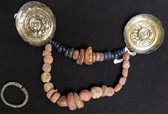
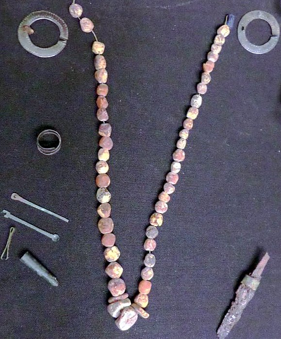
Fig 3 Top: disc shoulder brooches and linking amber beads for a small child; Bottom: a woman’s similar shoulder brooch & linking bead set plus finger rings, toilet set (tweezers, ear scoop, brush handle) and a small knife. Both images 450-700 AD from Bidford and both from the Shakespeare Birthplace Trust.
The amber beads in fig 3 are from the Baltic and although the knife is small and possibly decorative, the carrying of knives was normal for Anglo-Saxons. Were these people from Scandinavia or aspiring to look that way? The cemetery at Stretton-on-Fosse had 53 male, female and child burials dated to AD 495-600 and were considered to have all been members of an extended family (Ford 2003). Many males were accompanied by Anglo-Saxon spears and shields. Fig 4 below shows a burial where the head had been severed and replaced by a cauldron and the head placed on the stomach with the spear between the feet. It is difficult to know how to interpret the signals being expressed in this burial as the careful arrangement obviously meant something to the people who buried him but seem bizarre to us in the 21st century. The British went in for unusual burials and head cults (Cunliffe 1983). Was this a real Anglo-Saxon warrior or was he 80% British Hwicce?
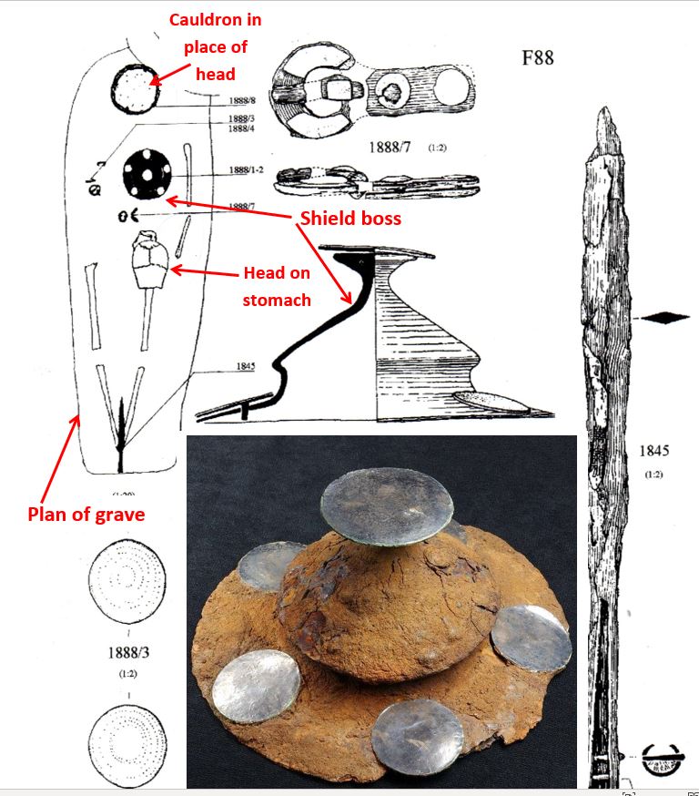
Fig 4 A male burial from Stretton-on-Fosse, accompanied by shield and spear. Grave plan and contents drawing from Ford 2003. Photograph of original shield boss (inset) from Shakespeare Birthplace Trust.
Also found at Stretton were two sunken-featured buildings that I mentioned above. These were Anglo-Saxon buildings like those frequently found in Continental Europe and which misled earlier archaeologists into thinking that Anglo-Saxons lived in pits, as pits in the ground are what are found archaeologically. They are now interpreted as workshops, weaving sheds and dry storage areas with a suspended floor above an air space for warmth and preventing dampness as illustrated in fig 5 - based on experimental reconstructions at West Stow Anglo-Saxon settlement near Bury-St-Edmunds.
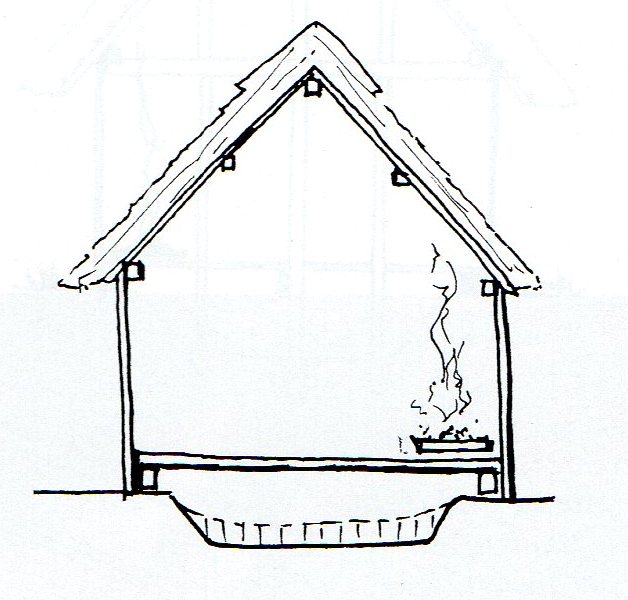
Fig 5 a reconstruction of a SFB (best thought of as a suspended floor building) at Stretton.
No burials or SFBs have been found in Ilmington but people must have been living here at this time because Anglo-Saxon pottery and a loomweight (which were often associated with SFBs) have been found in the village (figs 6 & 7).
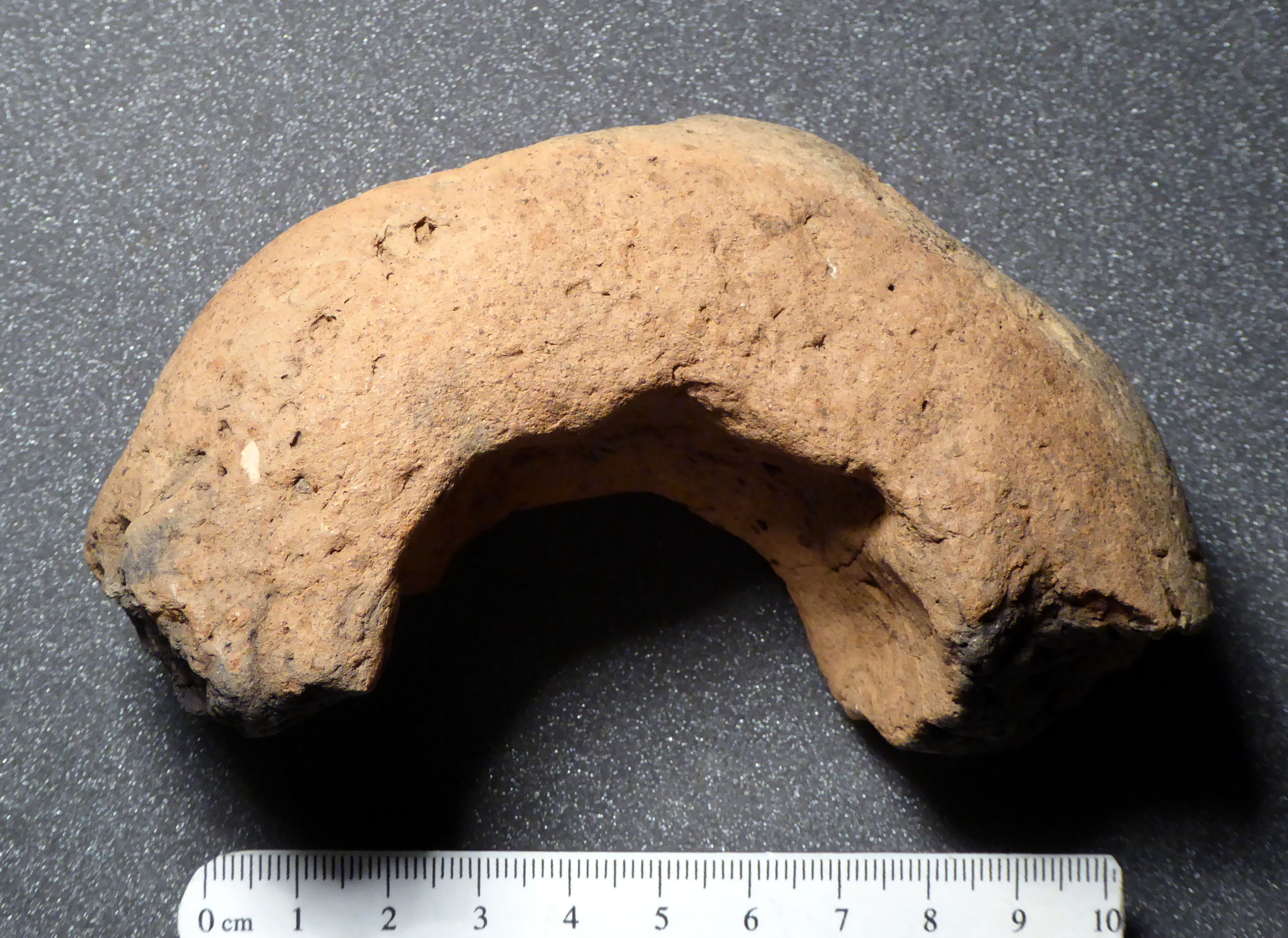
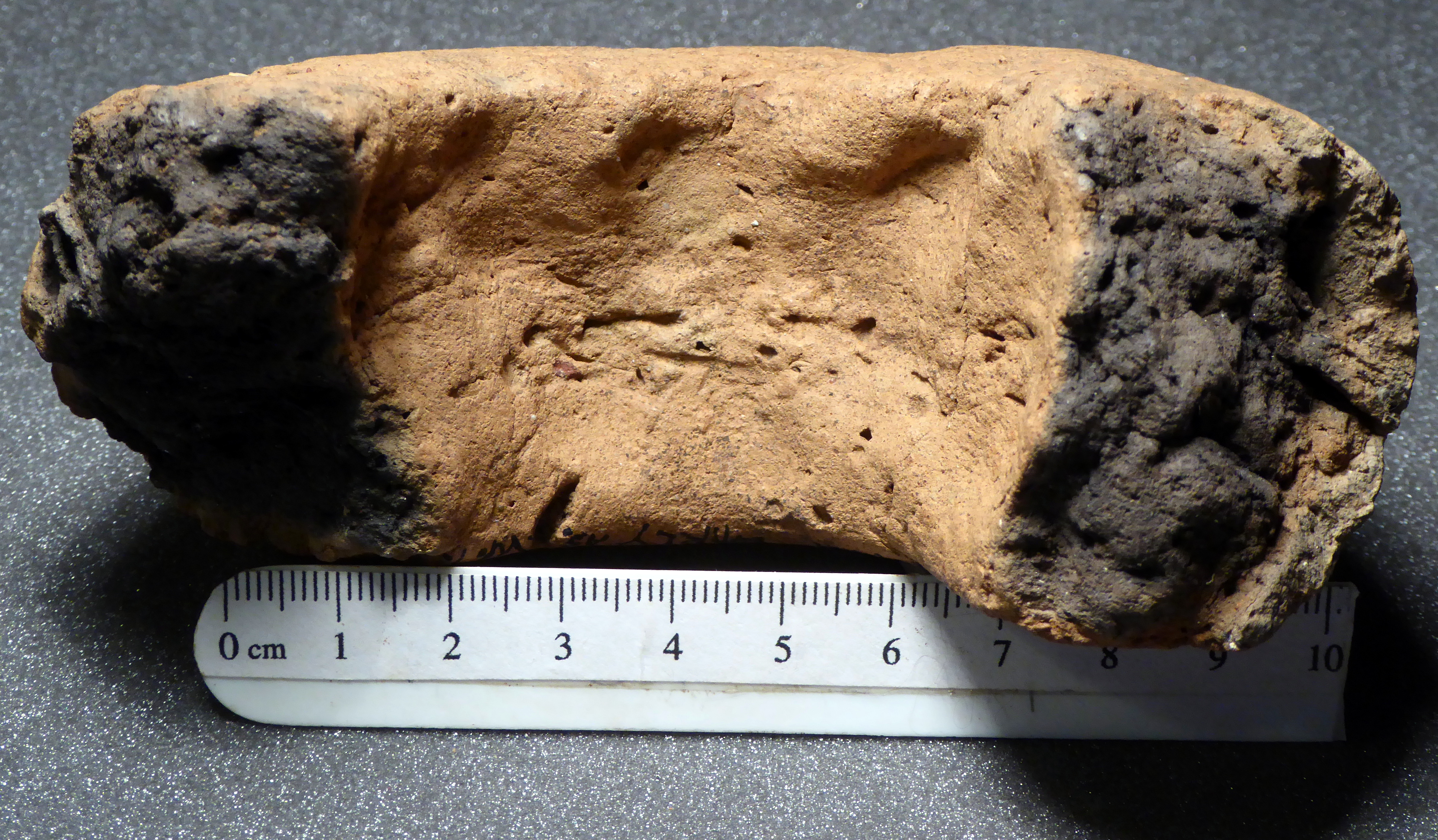
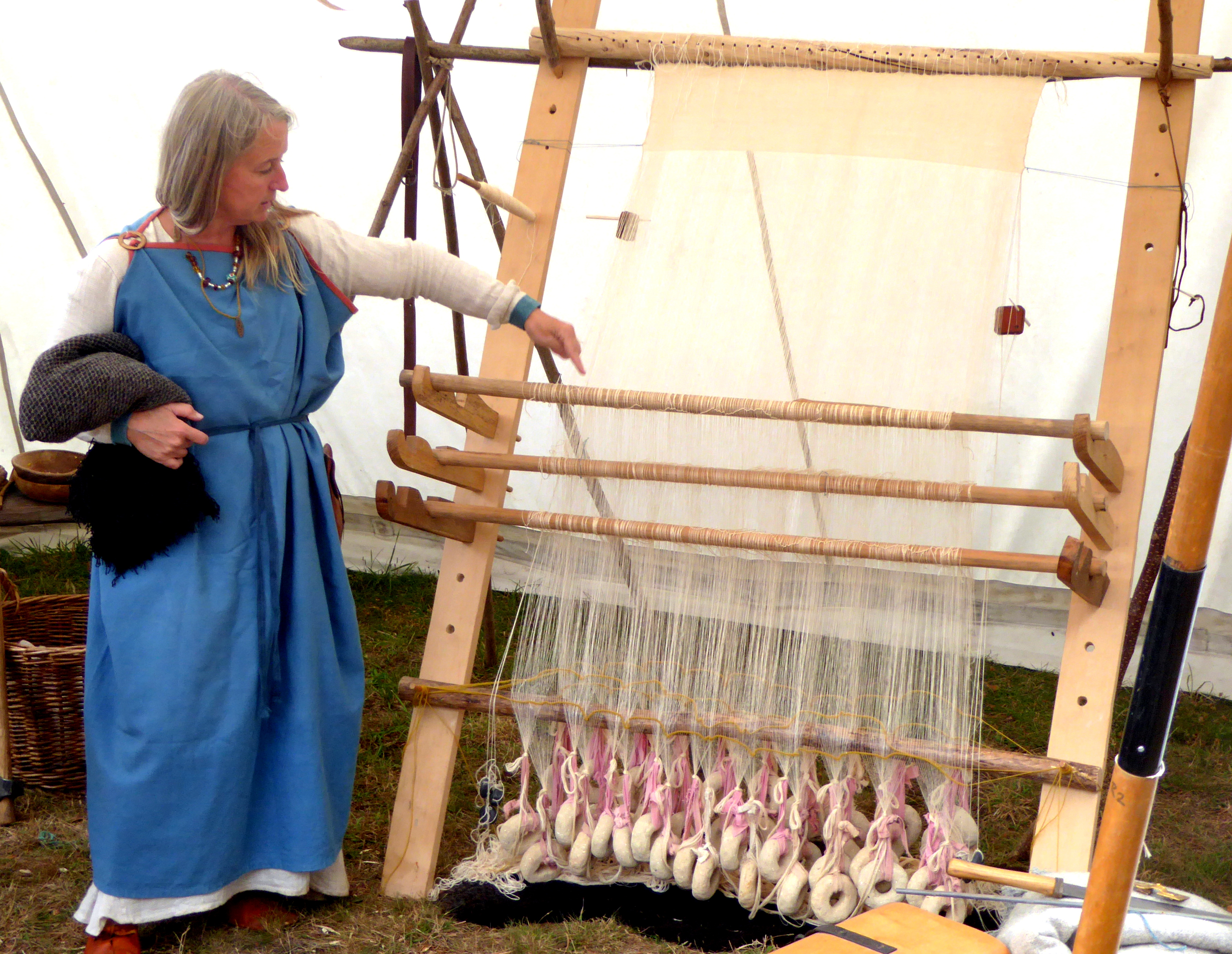
Fig 6 Top left: an Anglo-Saxon clay loomweight fragment from Hill Farm Barns Ilmington; Top right: 3 human finger impressions from when it was made; Bottom: loom weights in use on an Anglo-Saxon style loom.
The loomweight fragment was found by Peter Gardner when Hill Farm Barns were being converted to the current houses. It can be dated to 400-800 AD and such loomweights are often found on early to middle Anglo-Saxon settlement sites and seem specific to them (Leahy & Lewis 2018). A similar fragment was found by Professor Chris Dyer at Larkstoke. The very wide date range is typical of the problems with dating finds from this period because changes in Anglo-Saxon material culture were quite slow. The vertical looms on which the weights were used, were replaced with horizontal ones after 900 AD and generally, the larger the doughnut hole, the earlier they were made. The fragment in fig 6 has a line of 3 finger impressions (including fingernails) in its clay rim and as these are much smaller than the author’s, they were probably made by a child. They are the earliest visible human features of Ilmington’s community.
Peter Gardner also found some of the earliest Anglo-Saxon pottery, this time in Manor Farm Barns, Middle Street, when they also were being converted into residences. They have been identified as hand made early Anglo-Saxon pottery by Derek Hurst of Worcestershire County Archaeology (below fig 7).
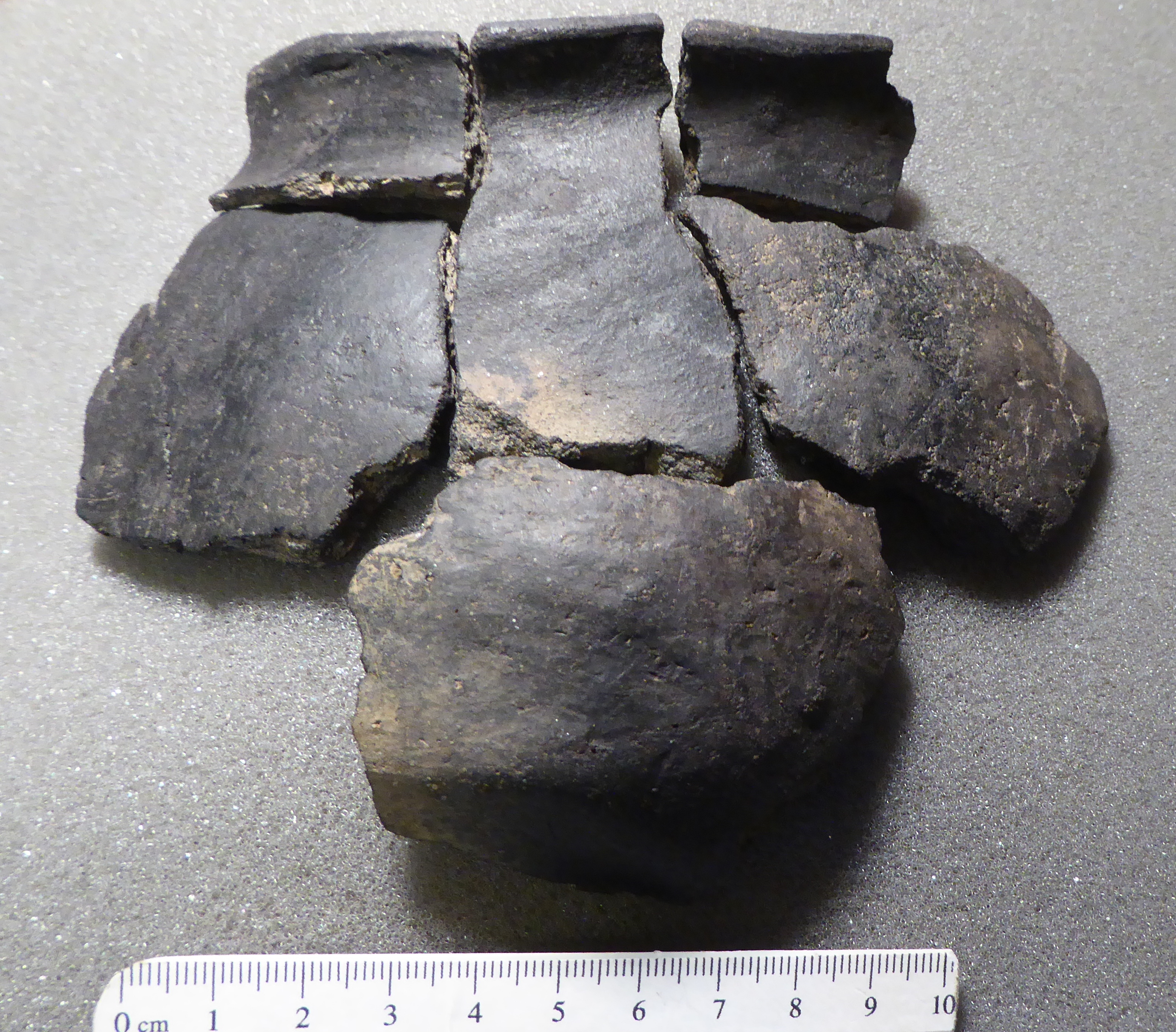
Fig 7 Early Anglo-Saxon pottery from Manor Farm Barns
The author arranged the sherds together to give an impression of the type of pot they would have come from, even though they are not all from the same pot and, although this is not acceptable archaeological practice at all, it gives a better visual impression. Compared to the wheel made Roman pottery of the preceding era, this is very crude and does not look like it was made by someone who earned their living as a potter. It was made by hand and even though the surfaces have been smoothed off by burnishing, it is still very lumpy and difficult to distinguish from Iron Age pots – a trick archaeological interview question – how do you tell Anglo-Saxon pottery from Iron Age pottery? Answer – you can’t.
So, fig 7 illustrates the genuine disruption to farming life at the end of the Roman period. If the farmer’s wife wanted a pot at this time, she had to make it herself and could not buy it at Dorn like her great, great grandmother.
Here then, is the evidence that there was some kind of settlement within the space between Manor Farm, Middle St and Hill Farm in Hurdlers Lane in the early to middle Anglo-Saxon period of 450-700 AD. But was it a village? The answer seems to be no, it was more likely a loose collection of separate family farms each with their own surrounding fields and no distinction between grander or lesser farms as they were all of the same size and construction as shown below. They were very possibly all from the same extended family. There is no evidence for the extent of this community, so it may have included Nebsworth as far away up the hill as the Ilmington Downs between Pig Lane and Campden Hill. Nebsworth comes from Cnaba or Cnebba’s farmstead enclosure or worth (Gover et al 1970 and Mills 1998).
It is possible to glimpse Ilmington’s Anglo-Saxon community by looking at ones that have been reconstructed exactly on top of their excavation sites. The most well-known one is West Stow in Suffolk (shown below in fig 8).
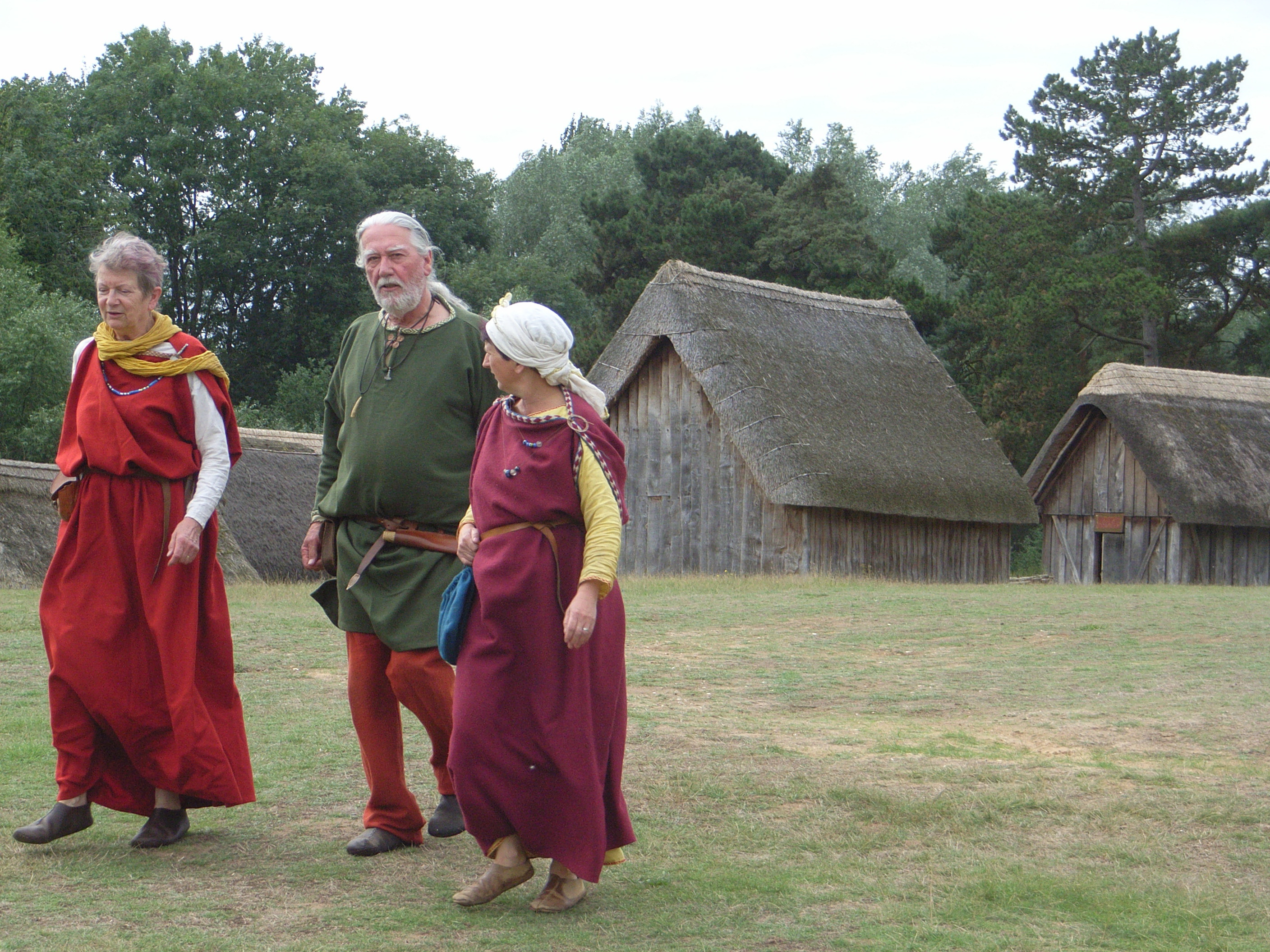
Fig 8 Re-enactors strolling through the reconstructed early Anglo-Saxon settlement at West Stow.
This settlement existed for over 200 years and left remains of over 69 sunken-featured buildings and ‘halls’ (West, 1999). At any one time only a fraction of these buildings existed as they were made entirely of wood and thatch and so had a limited (tens of years) lifespan. The halls, shown above, were about 10m long, larger than the SFBs and each acted as one family’s core ‘room’ surrounded by separate SFB workshops, rather like one giant house exploded into separate single units. There were no fences or boundaries between the three to four families making up the settlement, but towards the end of its 200-year life, ditches were dug to separate areas.
Bearing in mind what I have said earlier about the Hwicce from Ilmington and the fact that they may have been Welsh speaking up to the 7th century, it may be better to base a reconstruction on a site excavated closer to us at Ripple near Upton-on-Severn Worcestershire (fig 9) where an artist has recreated the settlement based on excavated features (Barber & Watts 2008). In the hundred years between 550 and 650 AD six SFBs occupied an area of about 100m by 60m or about the size of Upper Green in Ilmington.
Each SFB was about 5m by 3m so we may think of them as thatched wooden sheds that would comfortably have housed a VW Golf on their suspended wood floors. A total of 18 fragments of handmade Anglo-Saxon pottery and a few fragments of annular loomweights were recovered from three of the SFBs, dated to AD 450-850 and nicely matching Ilmington’s artefacts both in type and date range.
Fig 9 A recreation of the 7th century Anglo-Saxon settlement site at Ripple, Worcs, adapted from Steve Smith, Cotswold Archaeology.
Luckily three radiocarbon dates were obtained at Ripple to give a tighter AD 550-650 date for the site. No other artefacts were recovered but several ditches were partly preserved. While no exact parallels should be drawn between Ilmington and Ripple, there are similarities so that, at the moment, the image in fig 9, is the best way to think of the settlement at Ilmington in this period, especially as it hardly differs from West Stow in fig 8.
The Middle Anglo-Saxon Period AD 650 – 850 and the Spread of Christianity
There were major political, religious and economic changes at this time, but from an archaeological perspective, this period is almost invisible in our local area. There is nothing to compare to the explosion of recorded sites summarised in fig 2, (Alexander, Palmer & Chadd 2008). While there may have been clustering of kin-based farms, they were not yet united into organised villages and Blair (2018, p 298) refers to these clusters as semi-nucleated settlements which changed very little until the late Anglo-Saxon period. Unfortunately, the Hwicce sub-kings (I’m sure that ’sub’ rankled) had outlived their political role of providing a buffer state between Mercia and Wessex and they had disappeared by the late 770s, subsumed into ever expanding Mercia (Reynolds 2006). The period 600-850 is known as the conversion period and with its increasing re-Christianisation of the population by missionaries from Rome, there was an equivalent decrease in the burial of grave goods, hence the archaeological desert.
The spread of Christianity and the establishment of kingly territories went hand-in-hand with kings donating land to fund the establishment of minster churches, often administered by members of the royal families. One of the last acts of the Hwicce kings, Eanbert, Uhrtred and Ealdred, was to donate land in the centre of the Stour valley for the provision of a minster church to service the Stour Valley folk territory. After this the Hwicce kings disappeared, but their territory lived on to become the diocese of Worcester. The donated land effectively split the folk territory of the Stour Valley in two (fig 10).
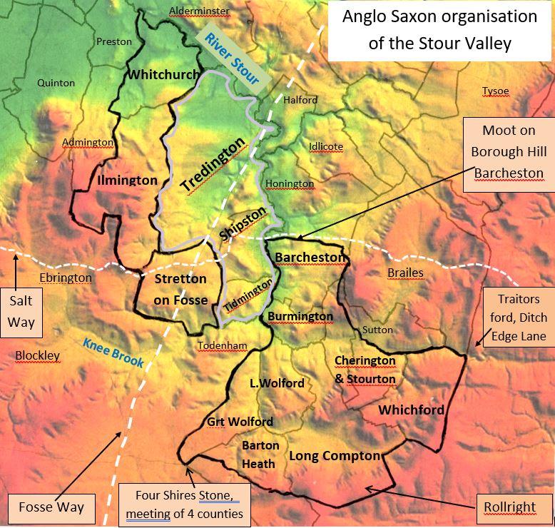
Fig 10 The administrative organisation of the Stour Valley. Barcheston Hundred is in two parts, heavily outlined in black. It was probably split when the central area of Tredington was donated to the church at Worcester. This territory became part of Oswaldslow Hundred in Worcestershire and is outlined in grey. The Hundreds and later parishes have been draped over the terrain of the area. Note the Saltway crossing the Stour at Shipston, running along the Barcheston boundary past the possible Moot site on Borough hill.
The Christianisation of the Hwicce was achieved through these minsters or ‘mother churches’ set up within each folk-territory (Barrett 1989). They should not be thought of as the churches familiar to us today, but as missionary centres with groups of priests circulating throughout the folk territory. Alexander, Palmer and Chadd (2008, p 63) suggest this applied to the detached Oswaldslow Hundred area and I suggest it applied to the whole valley. If this was the case, priests from Tredington would need agreed meeting points in the communities they were visiting and these may have been marked by a cross. In Ilmington, Cross Leys may have been one such place as it means ‘clearing or open space with a cross’.
Once established, the minsters often developed to become the high status settlements of their time (Blair 2005) and the charters associated with their establishment become such an important ‘Bill of Sale’ that quite a few were faked. It is in this middle Anglo-Saxon period that land starts to become ‘privatised’ for the first time (Barrett 1989). There are no charters specifically for lmington but luckily, Ilmington shares a border with Tredington and its component settlements of Blackwell and Longdon and we still have these three charters along with details of their boundaries. It is where we see Ylman dune (Ilmington) mentioned for the first time, so it is worth looking at them in some detail.
The translation of Tredington’s charter begins:
A.D. 757 Eanbert, Uhrtred and Ealdred, under-kings of the Hwicce, to Mildred, bishop, and St Peter’s Worcester, grant of 30 hides at Tredington, previously held by Tyrdda. (Hooke 1999)
What is so engaging about this little bit of information, is that it places local events at a time of kings or at least local sub-kings, ruling the Stour valley. It also gives us the precise date of 757 and then goes on to describe a circuit of Tredington’s territory although this may have been added later in the 10th century at the time of the Blackwell and Longdon charters (Hook 1999). A hide is the area of a single family farm, about 120 acres. The boundary circuit is written in Anglo-Saxon or Old English and conveys the reader to another world. For instance, it begins:
þis syndan þa landgemæ to Tredingetune
This seems completely unreadable and incomprehensible until you realise that ‘þ’ is pronounced ‘th’ and using a bit of elementary German, it becomes ‘These are the land boundaries to Tredington’. By combining the charters of Tredington, Blackwell and Longdon we can follow a small section of their boundaries with Ilmington on the modern ordnance survey map (fig 11).
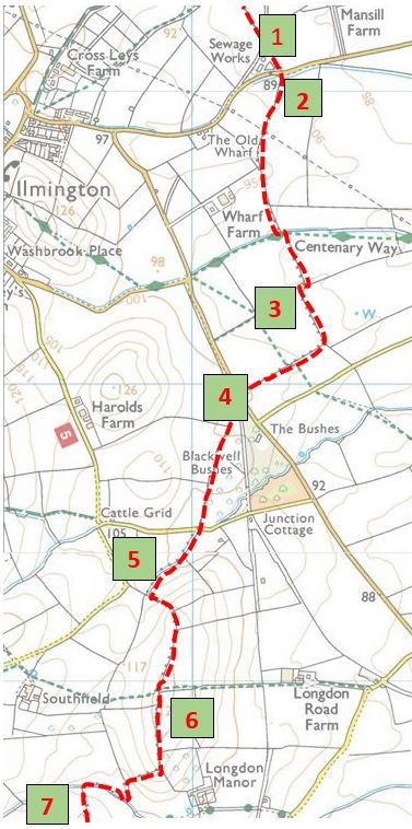
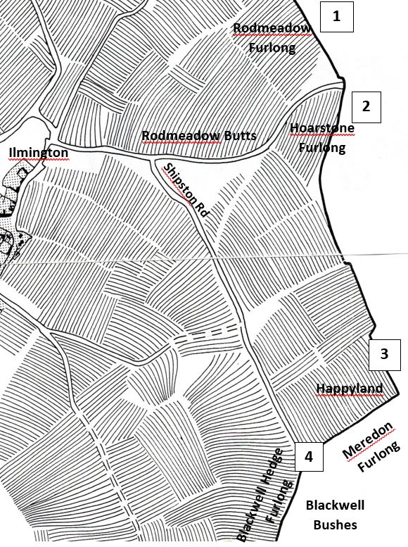
Fig 11 Left: Ilmington’s boundary with Tredington; Right: some of the furlong names between 1 and 4
The boundary clauses read as if we are walking from north to south following the landscape features.
1. ‘from the reed-meadow to the Hoar Stone’
The original names of the furlongs or blocks of ridge and furrow have been discovered (Gardner & Ibbotson 1974, map 3) and matched by Della Hook (1999) to these features. The area around Ilmington sewage works has many ‘rodmeadow’ names derived from the rods or reeds in this damp area. Hoar stones are ancient lichen-covered stones (hence grey as in hoar frost) often from Neolithic graves and used in the Anglo-Saxon period as boundary markers. This one is missing, but the name lived on in the road-side furlong.
2. ‘to the small stream to Ilmington’s boundary’
This is the stream that flows through Ilmington village and becomes the Back Brook at Blackwell. The phrase ylman dunes gemære is the first known reference to Ilmington as ‘elm hill’s boundary’ and comes from Blackwell’s charter of 978 AD, (for dune = hill, think of ‘sand-dune’ or ‘down’).
3. ‘from the Hoar Stone to the long ditch’
The boundary crosses a featureless zone of ploughed fields, so a man-made ditch was cut to mark the boundary. This follows the open field furlongs as shown by the tell-tale right-angle steps and bend at Happyland Furlong. This means that these ploughlands were already in place by 978 AD. If it had been unploughed meadow land, a straight line would have been cut between 2 and 4. These right-angle bends in what ought to be a straight line also occur in the roads round Ilmington. The field headlands were used as tracks indicating that many ploughlands came before roads.
4. ‘so to the boundary thorn’
The ploughed field next to Happyland is in Blackwell lands and was called Meredon Furlong where Mere means boundary. The ‘boundary thorn’ was a common feature of Anglo-Saxon boundary clauses and in this case coincides with Blackwell Bushes.
5. ‘to the reed spring’
This is the stream between the recently planted Flowers Wood and Blackwell Bushes. It rises at 5 where Angus Chambers has recently created a wild-life pond that still has reeds.
6. ‘to the ridge, along the ridge to the stone ford’
This is the long low hill east of Southfields Farm that gives Longdon or lang dune its name, where the boundary meets the next stream separating Compton Scorpion from Ilmington.
7. ‘from the stone ford along the watercourse south by the headlands’
Here the boundary is skirting round the enclosure headlands of the already-present and still visible settlement of 969 AD, south-west of Longdon Manor house. The distance involved is not great but the twists and turns require a lengthy written description.
It may be a surprise that the parish boundary is well over one thousand years old and that the written description is such an exact match for the modern map boundary, and it is one of the few ways for us to perceive the Anglo-Saxon countryside. It allows us special entry into that countryside as it seems remarkably like the one we are familiar with today. There were streams, meadows and low hills, ponds with reeds, blocks of ploughland with the odd thorn bush and (in Longdon) a ‘broad wagon way’. We do not hear of woods or forests around Ilmington nor of hedges and waste lands. So allowing for fewer people, less intensive agriculture, no hedges and tracks instead of roads we would recognise exactly where we were. Looking about us this is what we might have seen (recorded in a contemporary manuscript).

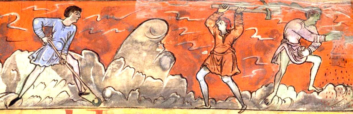
Note the single sided wooden spade with a metal cutting rim is more or less a foot-plough. Also, harvesting and shepherding seemed to involve a lot of people.
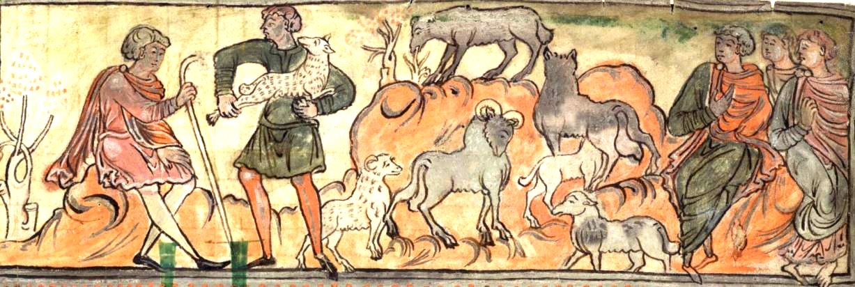
Illustrations from British Library, Cotton MSS Tiberius B.v.
So where did the people live? At this time, there were no towns, just loose communities of farming kinfolk ruled by a circulating court of sub-kings. The ‘royalty’ may have donated land to the church, but they still wanted to retain control over that land. Chris Dyer (2020) describes the struggle between the bishops of Worcester and the Hwicce sub-kings for control of the minster at Fladbury, on the River Avon west of Evesham. Winchcombe may have been the central place of the Hwicce but the princelings did not stay there. Both they and the bishops had a mobile lifestyle that involved traveling through their domain and living off the tributes of food and services provided as rent-equivalents by the farming communities. In the eighth century, this was more efficient than carrying food from outlying estates to a central household and allowed the sub-kings or the bishops to make personal contacts in every part of the territory over which they ruled (fig 12).
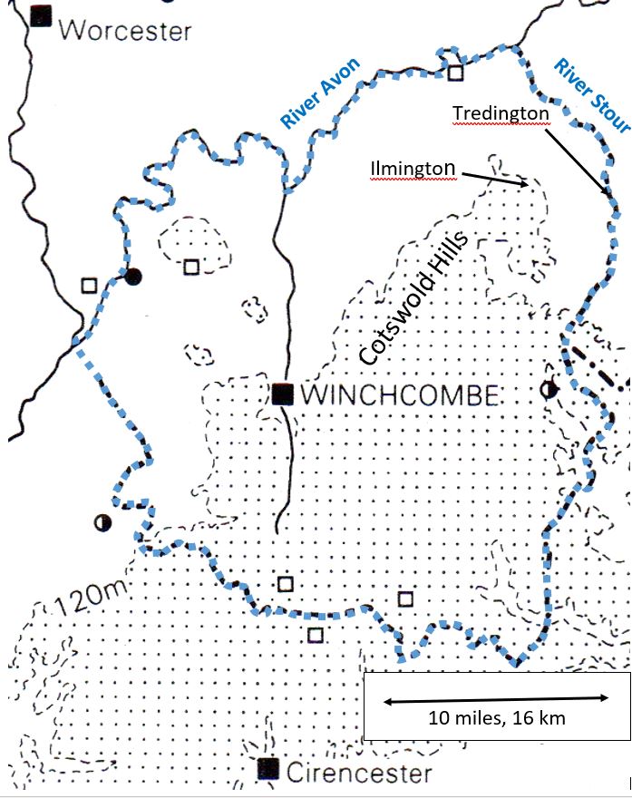
Fig 12 The core ferding of Hwicce territory that later became Winchcombeshire, outlined in blue. This is the area jealously retained by the last of the sub-kings. Adapted from Barrett (1989).
As the circuit of bishops and sub-royalty may have been expected to pass through the minster centre of Tredington, there would not just have been a permanent population of priests and monks but also visitors and servants all requiring food, lodging and attention. But Tredington’s fortunes seem to have declined with the Hwicce kings. There are a few Anglo-Saxon architectural features remaining in the church and a large ditch 100m to its SW may mark the precinct boundary (Alexander, Palmer & Chadd 2008) indicative of its earlier status when minster church surrounds also had a commercial role hosting markets and serving as meeting places.
The most likely candidate for dedicated commercial activity in our area is Bidford (fig 2) which not only has an extensive Anglo-Saxon settlement cemetery but also produced a range of finds and coins from the 8th and 9th century, indicative of a trading centre (Alexander, Palmer & Chadd 2008) (fig 13).
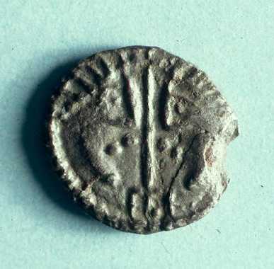
Fig 13 Both sides of an 8thC sceatta coin from Bidford, at least twice actual size. From ‘Our Warwickshire’
Bidford is notable as a communications hub where a Saltway from Droitwich and the Roman Ryknild St cross the navigable part of the River Avon and so make a logical location for an early trading centre (Richards & Naylor, 2010). At 12-15 km from Ilmington, it would be a long day’s journey to go to market there. Stratford and Shipston both have similar river, road and Saltway crossings (fig 10) and are nearer. Neither place is known to have a market until much later in the Middle Ages but would make obvious meeting places for informal trading at this period.
The Saltway crossing at Shipston (Neal’s Ford at the end of Watery Lane by the Black Horse pub) is also close to the Moot gathering point and law enactment centre for the Stour Valley (fig 10), proposed by the author. A Moot (as in ‘moot point’ or debateable point) was an outdoor assembly place for resolving conflicts, hearing royal decrees and for carrying out punishments. Borough hill on the Barcheston boundary derives its name from ‘barrow’ or ancient burial mound and is on the ‘no-mans-land’ parish boundary next to the Saltway in the centre of the folk territory. These features meet the criteria for identifying Anglo-Saxon outdoor assembly sites proposed by Baker & Brookes (2015). There is nothing remarkable about the hill.
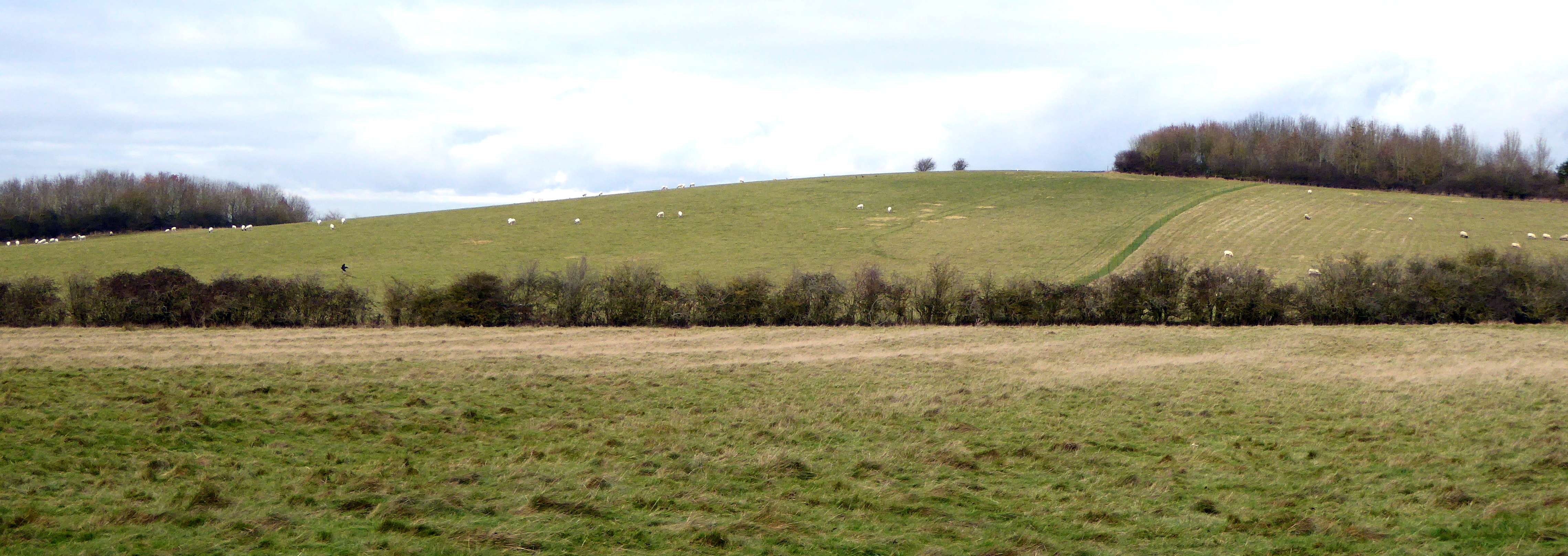
Fig 14 Borough hill, Barcheston. The possible Moot or Hundred meeting site for the Stour Valley.
So, for those wanting to visit a Moot, I would suggest the Kiftsgate stone, which is in a publicly accessible location just off the road, SW of Dover’s Hill above Chipping Campden and not at Kiftsgate at all. It was the meeting site for the Kiftsgate Hundred a huge administrative area of Gloucestershire.
Fig 15 The Kiftsgate outdoor assembly point for the Kiftsgate Hundred on the Chipping Campden border.
The Late Anglo-Saxon Period (850-1065) and Bury Orchard Burh
In the last 200 years of the Anglo-Saxon period, a lot happened. The village of Ilmington was formed along with its surrounding collective, open, ploughed fields of ridge and furrow. Its first church and manorial complex were established and, probably, the future village was laid out. We can say this with some certainty, not because Ilmington has had lots of archaeological excavations that reveal this to us (there has been one in Bury Orchard, with no Anglo-Saxon finds), but because the same thing was going on across much of central England at this time. We can use the results of other excavations and a remarkably useful letter from a well-known abbot to build a model of what probably went on.
Between 1977 and 1987 a huge, village-sized excavation took place in Raunds, Northamptonshire (Audouy & Chapman 2009) and this showed a very detailed sequence of events of how one particular village evolved during the period AD 450-1500, from the post-Roman period right through to the end of the Middle Ages (fig 16). The area excavated was roughly 400m by 300m equivalent to Back St down to Nellands Close and from the church to Hobday’s Bank in Ilmington. John Blair (2018, p 364) has recently completed a nation-wide assessment of similar late Anglo-Saxon excavations and regards Raunds as the most helpful in illustrating the events leading to village formation. Early in the 900s one of the traditional farmsteads expanded and was enclosed by a ditch and bank which at the time would have been called a burh. Around 950 and centred on this newly enlarged ‘long range’ house (see figs 22 & 23), a large grid of ditches was laid out, forming the basis for an expansive configuration of enclosures. By about 1,000AD a church had been erected and a graveyard established for the settlement. All pre-950 features had been swept away and some peasant plots occupied. This nucleated (or established) the village of Raunds, but only later in the Norman period between 1200 and 1400 with an expanded population occupying rows of houses, do we see a recognisable and familiar village organisation (fig 16 right-hand-side).
Taking this as a model I suggest that Ilmington may have formed in a similar way and at a similar time. If we take Ilmington to have formed by around 950, which the 978 Blackwell charter suggests it was by naming Ilmington’s borders, then the current village is well past its own millennium.
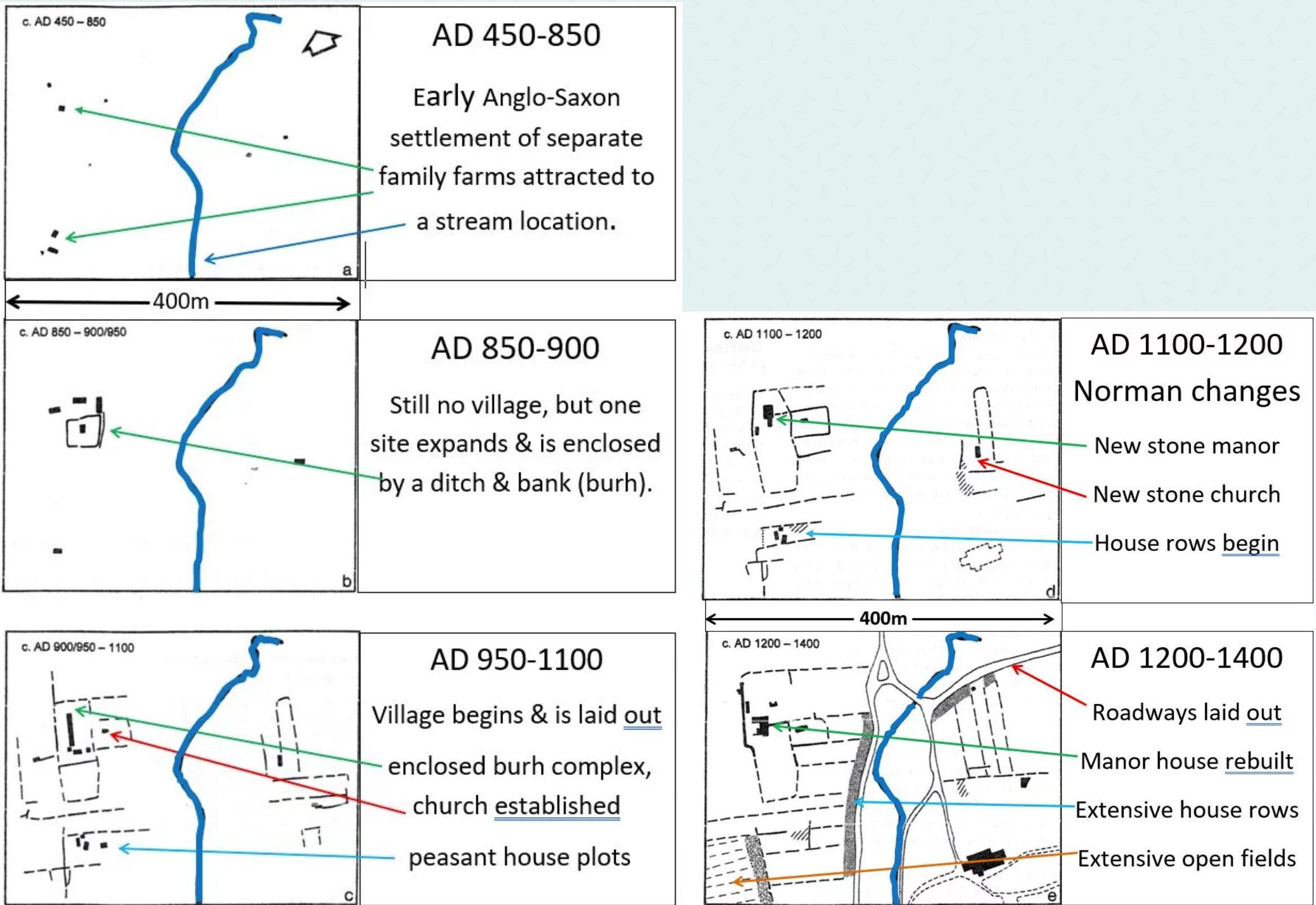
Fig 16 Left: the sequence of events leading to village formation at Raunds in the Anglo-Saxon period; Right: the changes that took place after 1066 in the Norman period leading to a familiar looking village.
Bury Orchard
Bury Orchard is a name that is not unique to Ilmington, for instance there are Bury Orchards in Southam, Hook Norton and Burford where they are associated with the church and manor house core of each settlement. Burh is Anglo-Saxon for a defended or fortified place, often taken to be substantially fortified, but perhaps not in Ilmington’s case or the burh in Saintbury 9 km or 5 miles from Ilmington (shown in fig 17).
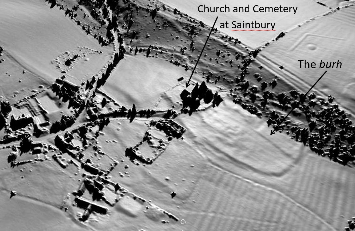
Fig 17 Saintbury church and surrounding burh revealed by Lidar imaging. (Lidar is a method of recording the topography of a site)
The topography shown in fig 17 reveals an oval enclosure of a slight bank and ditch containing a group of buildings, the parish church and a distinct entrance way. The enclosure has not been excavated or dated but Blair (2018, p 395) has suggested it is related to other oval-shaped, late Anglo-Saxon burhs associated with village formation rather than fortifications. The site at Saintbury is hardly a stronghold, being overlooked by a steep bank, set in open field ridge and furrow and having very modest defences. When Alistair Marshall (2020) recently revealed the enclosure ditch of the burh at Guiting Power, he showed it is also very slight indeed and usefully containing Saxo-Norman pottery for easy dating (fig 18).
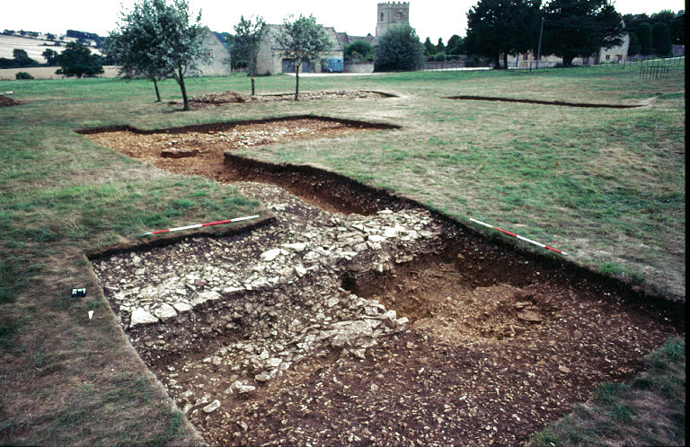
Fig 18, the late Anglo-Saxon burh ditch and bank at Guiting Power. (Each section of the red and white poles on the trench edges, measures 0.5m) (From Marshall 2020). Hidden behind trees in the background is the Norman manorial compound of manor house, village church and tithe barn.
The author is obviously suggesting that Bury Orchard is the remnant of the burh that began Ilmington’s formation, so do we have any evidence of this? There was a week-end excavation in 1976 before the fishponds were flooded (Ball, Holmes & Gardner,1976), but this investigated the moat bank and while plenty of roof tile and pottery from a 13th-14th century manor house was found, there was nothing earlier. Also in the 70s there was a trench to supply the electricity transformer pole and overhead distribution lines, but nobody seems to know where the trench was dug. Pottery from that trench includes no Saxo-Norman material. No one has looked for a burh enclosure bank and ditch and subsequently there has been a considerable amount of fishpond residue spread across the site which may confuse further excavations.
The pottery from this period is known as Saxo-Norman shelly ware (fig 19) because the clay contains fossil shells. It was manufactured for more than three hundred years, between 900 and 1200, with almost nothing to distinguish earlier Saxo-Norman sherds from later ones. One of its characteristics is the pitting of the pot surfaces where the shells in the clay have been leached out by water. Pottery with these characteristics has been found at Manor Farm Barns, Hill Farm Barns and in Frog Lane (Booth 1987), but none yet from Bury Orchard. So late Anglo-Saxon occupation of Ilmington village has been identified but, as far as Bury Orchard is concerned, we have very little to go on.
Bury Orchard was massively disrupted by the construction of the medieval moat and later fishponds which obviously involved rerouting the stream that used to run along the bottom of the gardens between Back and Middle Streets. It is not known if it has always run down Middle Street or whether this was a completely new route. A walk through Bury Orchard reveals a distinct bank and raised level on its boundary with Back Street but there has also been disruption here when roadside houses and a barn were knocked down in the last century.
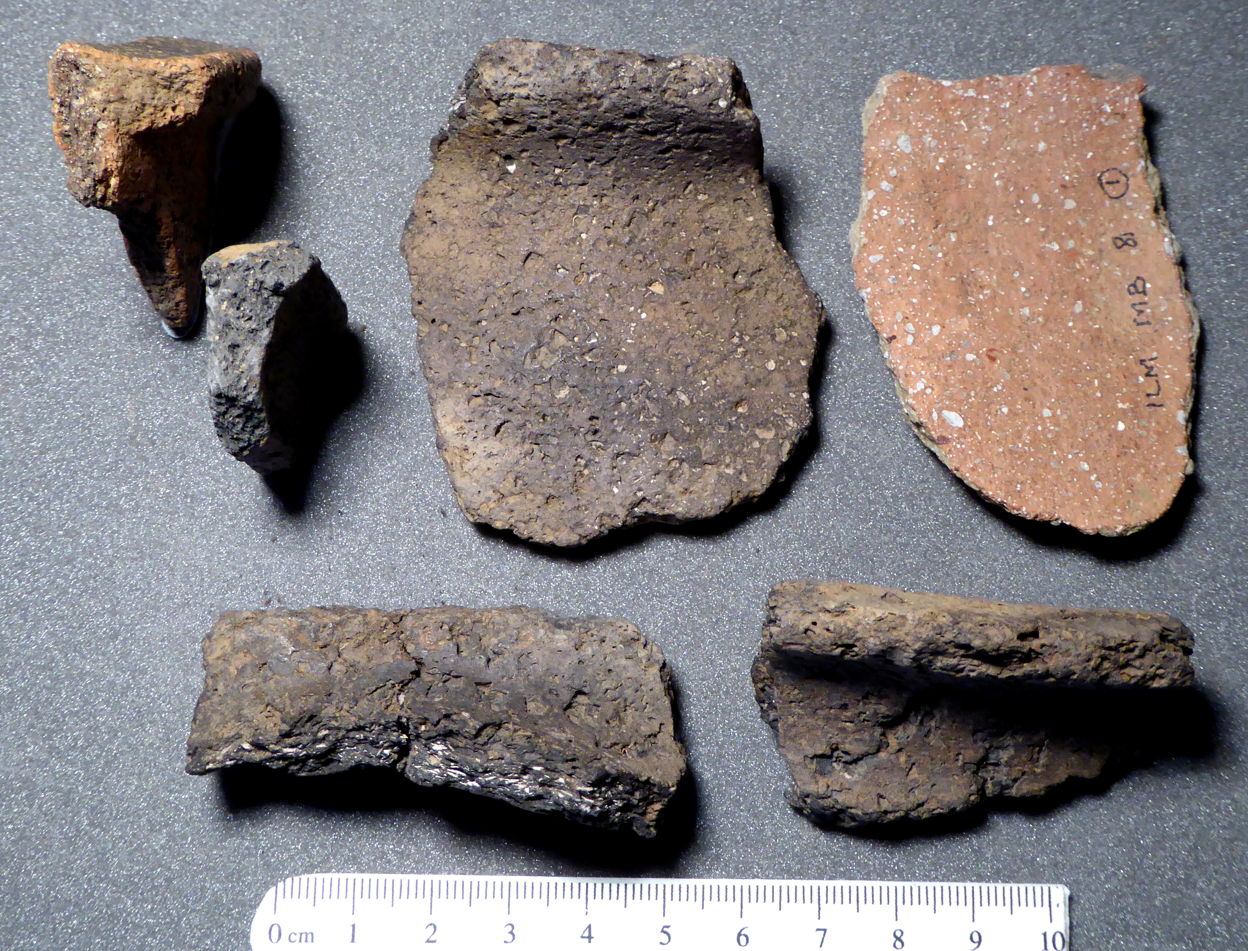
Fig 19 Saxo-Norman shelly ware from Manor Farm Barns and Frog Lane. Note the surface pits.
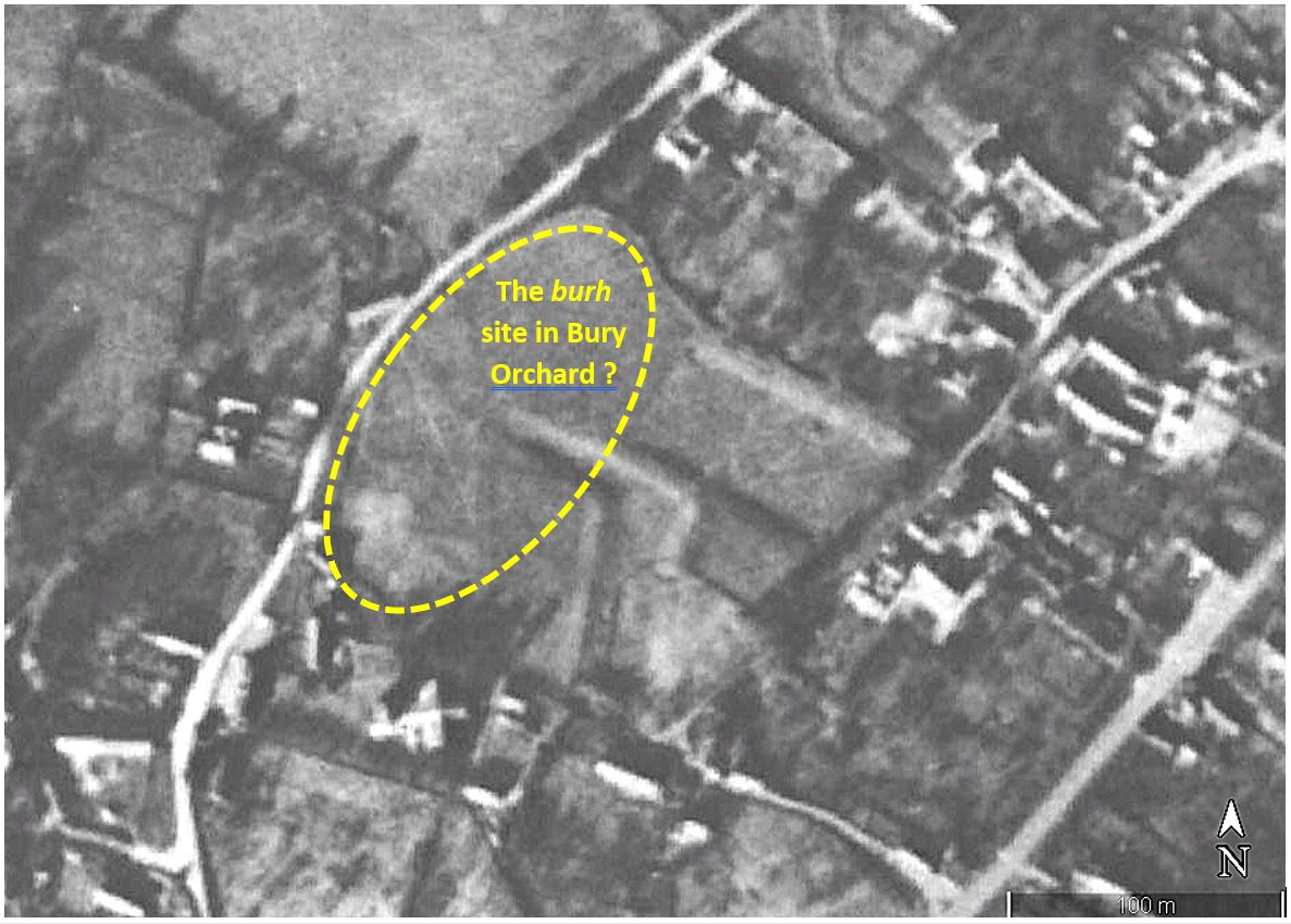
Fig 20 Bury Orchard in 1945 showing the medieval dry moat & fishpond and possible site of an earlier burh.
The only thing that can be clearly observed is an oval shape visible in the aerial photo taken in 1945 (fig 20) before tree planting and the flooding of the moat etc. to make the current ponds. The boundary with Sansome House is a deep curve not found in adjacent property boundaries. This curve is continued by the course of Back Street and Meadow View’s boundary to give an oval. Could this be one of the oval burh boundaries noted by John Blair and seen at Saintbury? At this stage, the answer is simply that nobody knows.
A final contribution to this story comes from a completely unexpected source – the writings of Abbot Aelfric of Eynsham Abbey (4km NW of Oxford). He was well known as a prolific writer of homilies or preaching texts for use by untrained priests with little Christian learning.
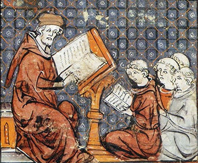
He was a monastic reformer writing Christian texts for the common man in vernacular Anglo-Saxon rather than Latin and, sometime between 1005, when he was in charge at Eynsham, and 1010 when he died, he wrote two letters to Wulfgeat (pronounced Wolf-yeet, probably) at Ilmington. Only one letter has survived and this only happened because Aelfric’s fame ensured that most of his writings were preserved. It begins:
‘I abbot Aelfric, in this English letter, greet Wulfgeat at Ylmandune in a friendly way, with God’s greeting. As we have both said about these English writings lent to you, you were well pleased with their contents and I said I wanted to send you some more …’. (translated by Ros Winter from Assmann 1889).
The letter is a lengthy presentation of biblical teaching, starting with the concept of the Trinity and going through angels and the devil to the origins of people, their redemption and final judgement, as if Wulfgeat was unaware of these fundamentals and as if the priests from Tredington had not been doing their job during the previous two centuries. It was replying to Wulfgeat’s request for Christian texts in English. He must also have asked Aelfric if drinking was sinful because about halfway through the letter Aelfric writes: ‘You love drunkenness and embrace heresy’ leading to a lengthy reply about what constitutes sin and how to behave as a Christian. So, initially the letter does not seem to be historically informative about Wulfgeat or Ilmington. Wulgeat was a reasonably common name at the time and we don’t know who this man was. Most Anglo-Saxon written material records elite life and is not concerned with the likes of Wulfgeat.
Luckily, Catherine Cubitt’s commentary on Aelfric’s letters to minor thegns provides us with additional insight into what was going on (Cubitt 2009). At about this time (1,000 AD) a text known as the ‘Promotion Law’ allowed the lowly ceorl (pronounced ‘churl’) to elevate himself to the status of ‘thegn’ once he had acquired ‘five hides of land (600 acres with accompanying workforce), a church and a kitchen, a bell-house and a fortress-gate, a seat and a special office in the king’s hall’ (Blair 2005, p 371). It was this status of local country landowner or thegn to which Wulfgeat seemed to be aspiring and to do that, he required a gated burh with accompanying church and bell and a place for social entertaining (the seat and kitchen). This cannot have come from nowhere and Wulfgeat’s family had probably been working at it since the late 9th C (the 850-900 stage illustrated in fig 16). He had to publicly demonstrate that he had 5 hides to fulfil the requirement to provide manpower for defence at the hundred or shire level and he would also have been directly responsible for ensuring that the local priest followed and obeyed the teachings of the bishops (Cubitt 2009, p 188). This is possibly the reason why Wulfgeat was writing to Aelfric rather than enquiring locally at Tredington. He needed to be able to judge the suitability of the priest he was employing for his church at Ilmington (which we know existed as it was recorded in the Domesday Book in 1086) and Aelfric was known for his concerns with clerical standards at grassroots levels. Also, Eynsham Abbey owned the manor of Mickleton just next door, so Wulfgeat possibly had local contacts with Aelfric.
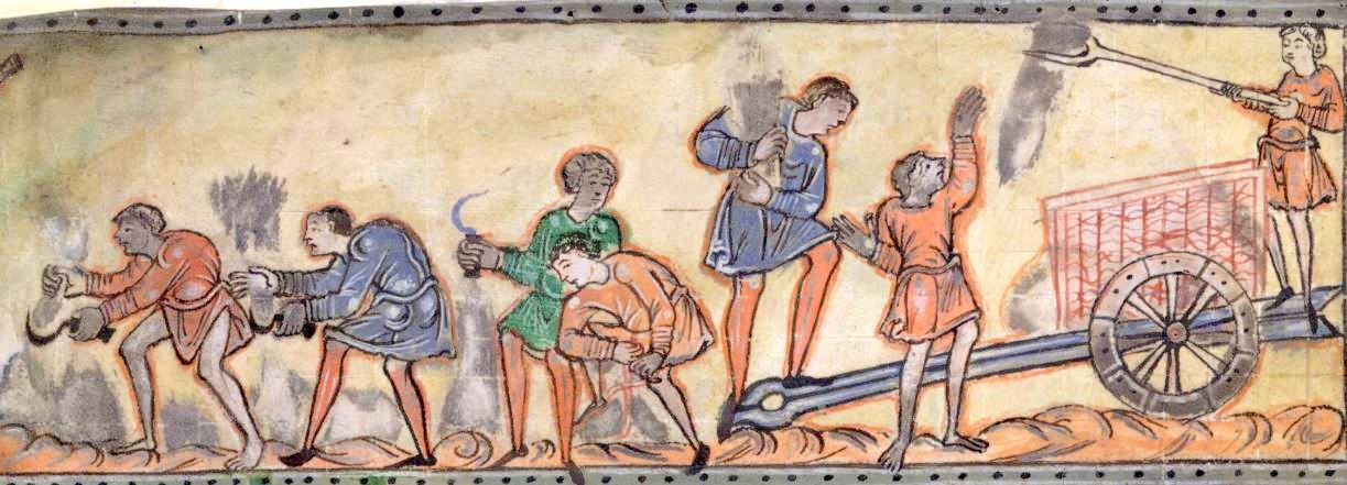
A man on the social climb could not get there without some help and backing from his community and this undoubtably involved entertaining with food and plenty of drink supplied by his kitchen (hence this odd specification in the Promotion Law) and may explain Wulfgeat’s enquiry about drinking (fig 21). If we were looking for a founder of Ilmington, it was possibly Wulfgeat and his forebears who may have built a burh in Bury Orchard and, along with the existing farmers, organised the settlement into a village.
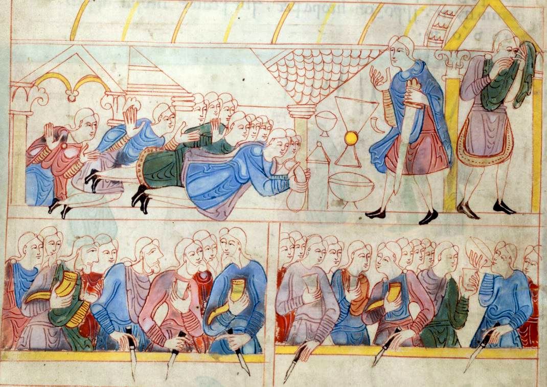
Fig 21 How to win friends and influence people in Anglo-Saxon times (from British Library Cotton MSS Claudius B.iv)
This is a flimsy story put together with only a few bits of evidence and some very thin links. For the moment, however, it is the best we can do to connect our few facts with current historical and archaeological thinking. Not only will that thinking change in the future, but so will some archaeology from the village as developers contribute to the shrinking of unoccupied spaces.
In the closing stages of the Anglo-Saxon period, the uniform size of earlier houses disappeared and grander domestic structures were built as illustrated by the reconstruction from Raunds (fig 22).
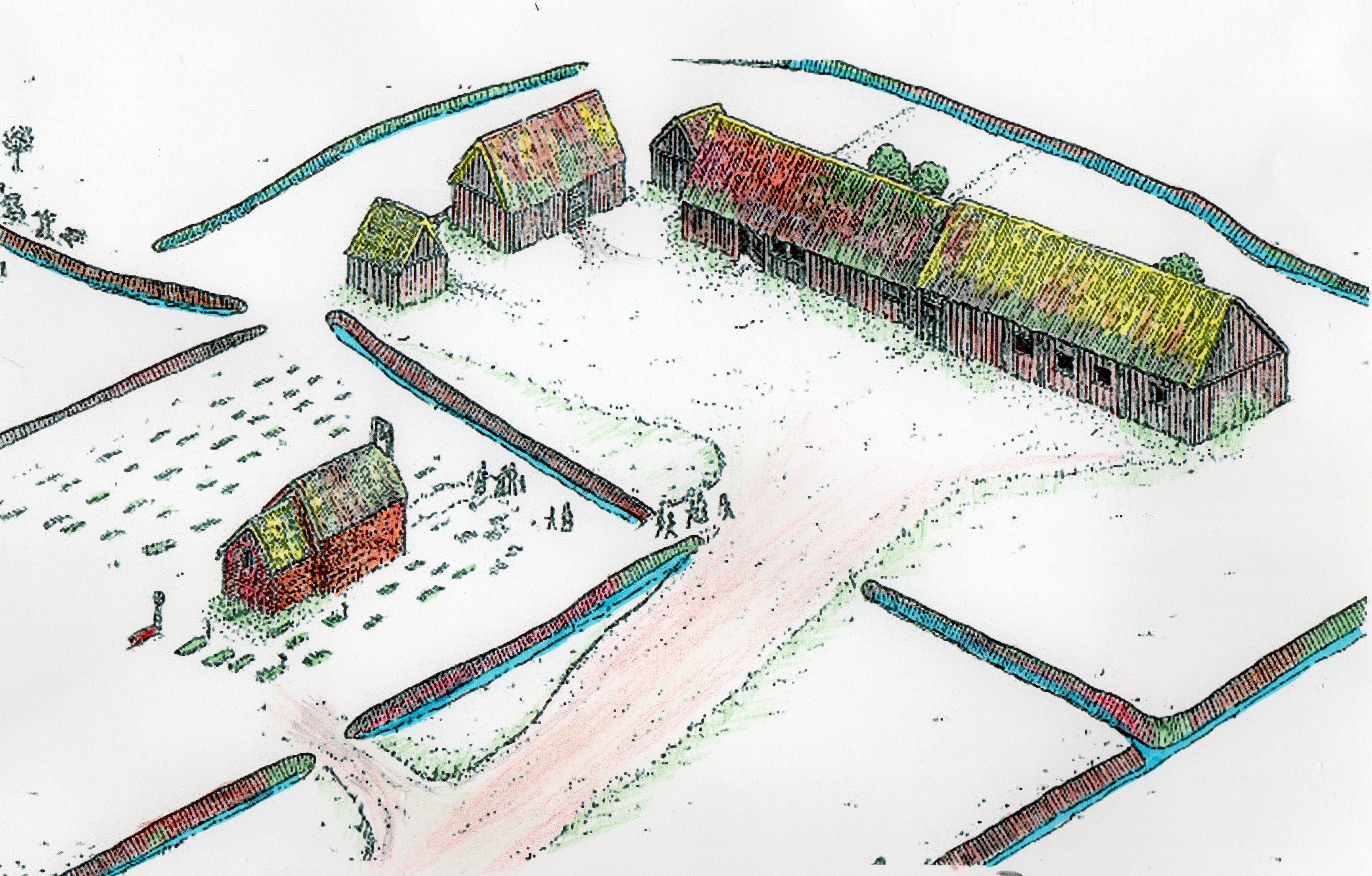
Fig 22 An artist’s impression of the manor house and church and graveyard complex at Raunds 950-1100. Note the ditches providing a planned space (adapted from Audouy & Chapman 2009).
It is not known if Wulfgeat’s family was affluent enough to really show-off, but if they were, their residence in Bury Orchard may have looked like the wooden ‘long range’ house in fig 23, very different to the earlier houses of figs 8 & 9.
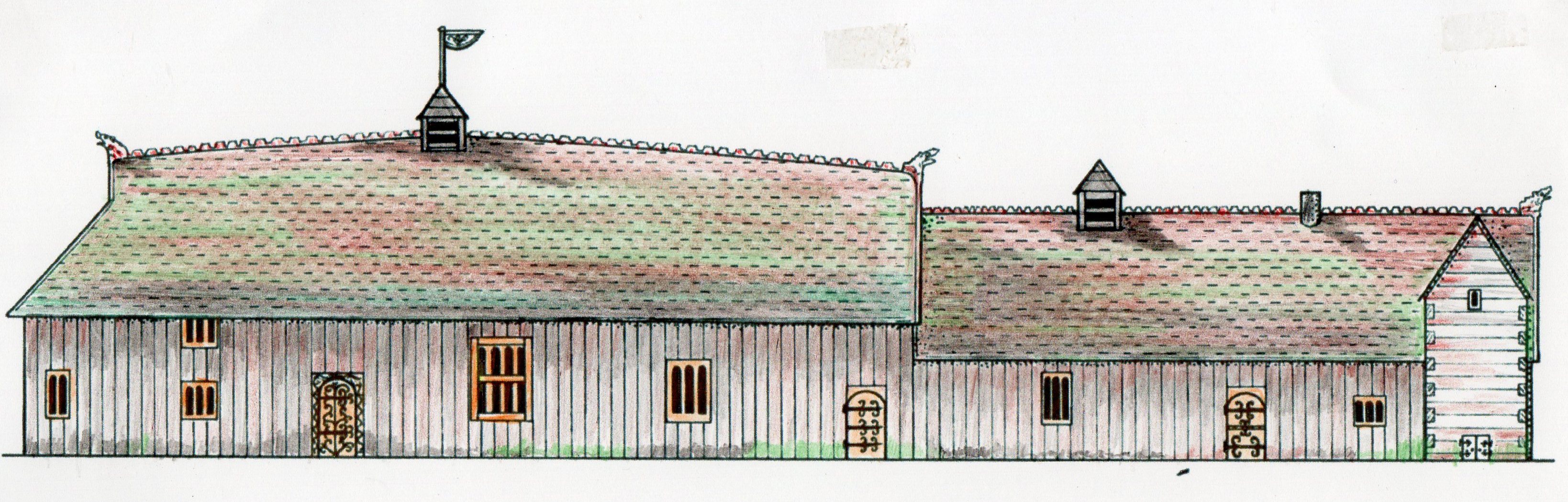
Fig 23 A generalised reconstruction of a ‘long range’ house 950-80 (adapted from Blair 2018).
Lastly, it is worth briefly considering the idea that parts of Ilmington village were planned out from this time.
The excavators of Raunds were convinced there was evidence of a planned allocation of house plots allowing for future expansion of the village. Ditches were cut in a grid of one acre plots both at Raunds and neighbouring West Coton (see figs 16 & 22 above) (Audouy & Chapman 2009, p 30). John Blair has promoted this idea although using a measure of ‘short perch’ lengths instead of Chapman’s rod length (Blair 2013). Mick Aston & Chris Gerrard (2013) in their 10 year excavation of Shapwick, Somerset, found a ladder shaped plan to the Anglo-Saxon origin of their village. Obviously not all villages can have been laid out this way, especially in hilly terrain like Ilmington. So, more or less as an academic exercise, the author has overlaid a 10 short perch grid (1 short perch = 15 ft or 4.6m) on a map of Ilmington in fig 24 and surprisingly the middle to northern part of the village roughly fits that grid.
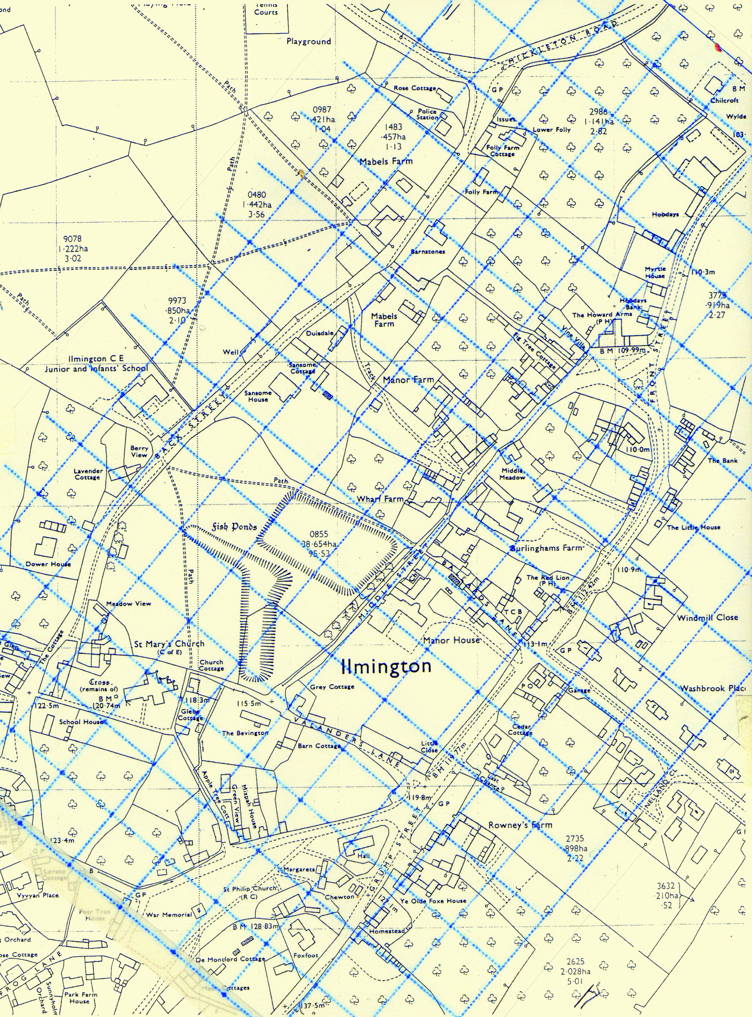
Fig 24 A post-war Ordnance Survey map of Ilmington overlaid with a blue, 10 ‘short perch’ grid aligned on Middle St.
The overlay is centred on the junction of Ballards Lane with Middle Street and aligned along the length of Middle Street. It is intended to be checked against the streets, pathways and land boundaries between house plots because these do not change over the very long term. These show no grid alignment in the southern hilly part of the village. However, starting at the right angle bend created in the stream at the northern end we can see that the grid fits with the land boundaries round Hobdays and Whitehouse Lane and further along Middle Street up to the boundary between Manor Farm and Wharf Farm. There is a nice two-grid fit between Middle Street and Front Street. Strangely, all the houses on the northern end of Back Street are aligned on the grid and don’t follow the bends in the road.
So it seems that some kind of vestigial framework of its Anglo-Saxon beginnings still remains in Ilmington and you can see it by just walking along Middle Street. You do have to remember, however, that most of the width of Middle Street has been ‘borrowed’ by the later properties on its edges, which is why it narrows so much. If you look at the foundations of the Doll’s House on the corner with Ballards Lane, you will see that an earlier house’s front ended four feet further back up Ballards Lane. Well, nobody was using Middle Street at the time! Put this evidence together with the finds from Manor Barns and Hill Farm Barns and we can safely claim that the Ilmington as we know it today had its origin in late Anglo-Saxon times.
Brian Meredith March 2021
References
Alexander M., Palmer S. & Chadd L. (2008) Post-Romano British and early medieval. In Archaeological Resources Assessment of the Aggregate Producing Areas of Warwickshire & Solihull. Warwickshire County Council Museum Field Services.
Assmann B. (1889) Angelsachsische Homilien und Heiligenleben. Georg H. Wigand.
Aston M. & Gerrard C. (2013) Interpreting the English Village: Landscape and Community at Shapwick, Somerset. Windgatherer Press.
Audouy M. & Chapman A. (2009) Raunds: The Origin and Growth of a Midland village AD 450-1500: Excavations in North Raunds, Northamptonshire 1977-87. Oxbow Books
Ball S., Holme J. & Gardner P.J. (1976) Excavations at Ilmington 1976: Bury Orchard. West Midlands Archaeology 1976
Baker J. & Brookes S. (2015) Identifying outdoor assembly sites in early medieval England. Journal of Field Archaeology. Vol 40 (1) p 3-21.
Bassett, S. (1989) In search of the origins of Anglo-Saxon kingdoms. In Bassett S (Ed.) The Origins of Anglo-Saxon Kingdoms. Leicester University Press
Barber A. & Watts M. (2008) Excavations at Saxon’s Lode Farm, Ryall Quarry, Ripple 2001-2. Transactions f the Worcestershire Archaeological Society. 3 ser. Vol 21 p 1-90.
Blair J. (2005) The Church in Anglo-Saxon Society. Oxford University Press
Blair J. (2013) Grid-planning in Anglo-Saxon settlements: the short perch and four perch module. Anglo-Saxon Studies in Archaeology and History. Vol 18 p 18-55.
Blair J. (2018) Building Anglo-Saxon England. Princeton University Press.
Booth P. (1987) Pottery from Ilmington, Warwickshire. Unpublished report from Warwickshire Museum.
Coates, R. (2013) The name of the Hwicce: a discussion. Anglo-Saxon England. Vol 42 p 51-61.
Cubitt C. (2009) Aelfric’s lay latrons. In Magennis H. & Swan M. (Eds) A Companion to Aelfric. Brill.
Cunliffe B. (1983) Danebury Hillfort. Tempus Press.
Dyer C. (2020) The historical background of the Pre-Conquest site at Fladbury, Worcestershire. In Hinton D.A. & Peacock P.S. (2020) Impinging on the Past: A Rescue Excavation at Fladbury Worcestershire, 1967. Highfield Press.
Ford, W.J. (2003) The Romano-British and Anglo-Saxon settlement and cemeteries at Stretton-on-Fosse, Warwickshire. Transactions. Vol 106 p 1-114.
Gardner S.M. & Ibbotson E.M.H. The History of Ilmington. TRUEXpress, Oxford.
Gover J.E.B. et al (1970) The Place-Names of Warwickshire. Cambridge University Press.
Harke H. (2011) Anglo-Saxon immigration and ethnogenesis. Medieval Archaeology. Vol 55 p 1-27.
Hooke D. (1999) Warwickshire Anglo-Saxon Charter Bounds. Boydell Press.
Hooke, D. (2011) The post-Roman and the early medieval periods in the west midlands: a potential archaeological agenda. In Watts, S. (ed.) (2011) The Archaeology of the West Midlands: A Framework for Research. Oxbow Books.
Hughes S. et al (2014) Anglo-Saxon origins investigated by isotopic analysis of burials from Berinsfield, Oxfordshire. Journal of Archaeological Science. Vol 42 p 81-92.
Hunt, J. (2016) Warrior, Warlords & Saints: The Anglo-Saxon Kingdom of Mercia. West Midlands History Ltd.
Jones, R. & Page, M. (2006) Medieval Villages in an English Landscape: Beginnings & Ends. Windgatherer Press.
Leahy K. & Lewis M. (2018) Finds Identified: An Illustrated Guide to Metal Detecting and Archaeological Finds. Greenlight Publishing.
Marshall A. (2020) The Later Saxon and Early Norman Manorial Settlement at Guiting Power, Gloucestershire: Archaeological investigation of a Domesday Book Entry. Archaeopress.
Mills A.D. (1998) A Dictionary of English Place-Names. Oxford University Press.
Our Warwickshire www.ourwarwickshire.org.uk (accessed 21 February 2021)
Reynolds A. (2006) The early medieval period. In Holbrook N. & Jurica J. (eds) 25 Years of Gloucestershire Archaeology. Bristol & Gloucestershire Archaeology Society
Richards J.D. & Naylor J. (2010) A ‘productive site’ at Bidford-on-Avon, Warwickshire: salt, communication and trade in Anglo-Saxon England. In Worrell S et al (eds) (2010) Proceedings of the Portable Antiquities Scheme Conference 2007. BAR British series (520). Archaeopress.
Rippon, S.J. (2017) The Fields of Britannia: Continuity and Change in the Late Roman and Early Medieval Landscape. Oxford University Press.
Sayer, D. (2017) Why the idea that the English have a common Anglo-Saxon origin is a myth. The Conversation. Dec 15
West S. (1999) Understanding West Stow. West Stow Anglo-Saxon Village Trust
Williamson, T. (2003) Shaping Medieval Landscapes: Settlement, Society, Environment. Windgatherer Press.